An Equal Area Projection for World Maps
It is possible to controll the distortions mathematically. Some constraints can be hold for the whole projection.
Nowadays more the 400 projection methods are known. Not all projections are able to map the whole world.
Equal area projections are supposed to be used when you want to compare sizes on maps. The Equal Earth Projection is a new projection method for equal area world maps and was developped in 2018.
Characteristics
The Equal Earth Map Projection is define to map the world as a whole with an outline of a curved shape to show that the earth’s figure is an approximation to a sphere, but the poles are mapped as straights.
It is an equal area projection: it preserves the areas locally and is used when relative size matters.
| Extrinsics: | Pseudocylindric |
| Intrinsics: | Equal Area |
| Area of Use (Extent): | World |
The Graticule
The outline of the map has a curved shape to show that the earth’s figure is an approximation to a sphere, but the poles are mapped as straights.
Normally used in the normal aspect: northern and southern hermispheres are mapped symmetrically with respect to the horizontal, straight equator. The natural origin of the map projection lies on the equator and on the intersection with the central meridian witch is also straiht. The poles are mapped as straight lines. All parallels and poles are parallel to the equator. All meridians other than the central meridian are curved lines.
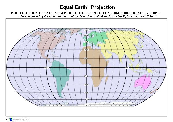
- poles are mapped as straight lines parallel to the equator
- equator, parallels and poles are straight lines and parallel
- central meridian is a straight line
- other meridians are curved lines
- equator is NOT equidistant
Projection Parameters
in the normal aspect (projection origin on equator)
- Central Meridian
- Orientation (what is up. North, South)
Known Implementations
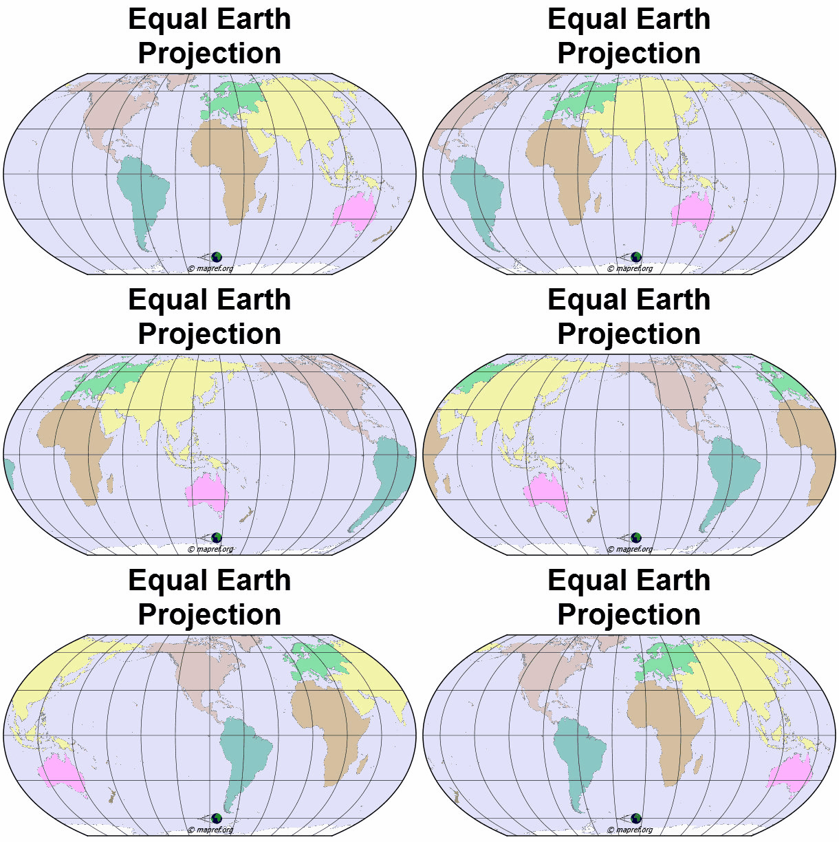
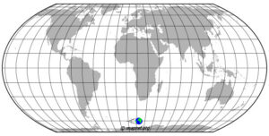
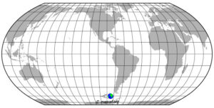
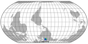
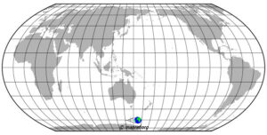
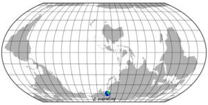
| Central Meridians | Value | Map Focus | Orientation |
|---|---|---|---|
| Greenwich | 0° | Europe, Africa | N |
| Florence | 11° 15' E | Europe, Africa the Florence meridian (11°15′ E) used to cleanly separate Asia and North America at the Bering Strait without awkwardly splitting landmasses. | N |
| 90° W | North and South America | N or S | |
| 150 ° E | Oceania | N | |
| 150° E | Oceania, Australia | S |
 |
 |
 |
 |
 |
 |
Projection Distortions (Intrinsics)
The Tissot Indicatrix is a method to analyse the distortion behavior of a map projection. An infinitesimal small cirle on the earth model generally is mapped to an ellipse (=Tissot Indicatrix).
A map projection is claimed “Equal Area” when in all points of the projection, the indicatrices have the same areal size. But in most points, the indicatrices are no circles and vary in shape.
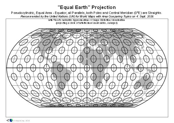
- all projected Tissot Indicatrices have the same area = equal area intrinsics
- the shape of the Tissot Indicatrices vary in each point (size and orientation)
- in Equator area, the lenghtes get longer in direction of the meridians and shorter in east-west direction
- because the poles are projected as a line, the east-west distortion increases when nearing the poles
Formula
developped / published 2018 by Bojan Šavrič, Tom Patterson & Bernhard Jenny
in the International Journal of Geographical Information Science.
Popularity
On 4th September 2026, the United Nations General Assembly voted for a resolution which “encourages governments, schools, international organizations and technology companies to use the Equal Earth projection and other so-called equal-area maps when relative size matters, matters, and to teach the limitations of any flat map in representing a spherical planet.” [UN-Web 2026]
The Crux of “Equal Earth” – The Projection doesn’t project equally at all
The Equal Earth Projection has the intrinsic geomeric property of equal area. As all equal area projections, the size of areas keep locally equal, but the shape and angular distortions vary.
The name “Equal Earth” is confusing: each point of the map has a different distortion behaviour. This behaviour also have other equal area projections, especially pseudocylindric ones.
- In “nature” (on the earth model) all meridians are “straight” (no curvature in its horizontal plane = called geodesic, on a sphere: great circle), but when you look at the graticule, only the central meridian keeps straight. The farer away from central meridian, the curvature increases, but is not constant.
- Lines of constant latitude (parallels) in nature have a curvature except Equator, the parallels in the projection are straight and are parallel to each other.
- As the poles are large lines instead of points in nature, in areas near the poles, the areas get large stretches in east-west, whereas in equator regions, they are shrunk in east –west.
- When you look at the Tissot Indicatrices, each point of the map has a different distortion behaviour. This can also be seen by the image of the meridians.
- The Central Meridian: it is not only a symmetry axis for the distortions, it also says that what is in the center of the map has e.g. low curvature of meridians. The samples of in maps applied central meridians show impressively how the continents get deformed. When presenting Europe or Africa, with Central Meridian Greenwich or Florence, you are also happy with the shapes, but not, wenn you use the American or Oceania version.
This means, The Central Meridian favors the equality of regions around the Central Meridian and not too near the poles.
Other Equal Area Projection for World Maps
there exist various other Equal Area Projection Methods for World Maps.
see e.g. “Map Projection Selection by Regional Use”
latest version: 01.10.2026
first published: 16.09.2026


Add a Comment